NIST Traceable Targets for 3D Laser Scanning
Leica Geosystems introduced a new tool that definitively validates the accuracy of forensic 3-D laser scans made using the Leica Geosystems ScanStation C10. The ScanStation C10 is an easy-to-use, compact and portable long-range 3-D laser scanner that can capture 50,000 measurement points per second and features an internal digital camera for capturing panoramic photography. This technology is used globally by law enforcement agencies for crime scene investigation, vulnerability and threat assessments, post-blast investigation, police action inquiries, accident investigations and more. The new validation tool is designed specifically to help crime laboratories and crime scene units achieve ISO/IEC 17020 and 17025 accreditation.
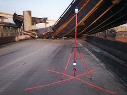
The tool builds upon Leica Geosystems’ patented twin-target pole for 3-D laser scanning, long used by police agencies all over the world to provide a simple and intuitive way for police (and jurors) to understand that the ScanStation is collecting accurate data. The twin-target pole has a designed distance of 1.700 meters between the two targets. To achieve National Institute of Standards and Technology (NIST) traceability, Leica Geosystems has contracted with the Large Scale Coordinate Metrology Group at NIST to perform individual calibrations on specific Leica Geosystems twin-target poles by carefully measuring multiple times between the target centers on each end of the pole (artifact) using a wavelength-compensated helium neon linear interferometer. NIST then applies serial numbers to each target system and generates a Report of Calibration that is provided to Leica Geosystems customers.
